


Students of the Myanmar’s Ministry of Construction training college on the outskirts of Yangon sit patiently listening in an open humid room, their tools stacked under their chairs.
At face value, the class would appear to be yet another lesson in theory for for Yangon’s future builders, a standard curriculum for a vocational college.
But there is a crucial component added to the tuition in this class that speaks to Myanmar’s need to protect its citizens in the event of a massive earthquake.
Architects and building standards officials are seeking to pass on crucial knowledge to provide professional level building practices that take into account the danger posed by earthquakes.
In simple language, the aim is to train builders to erect buildings that are not going to fall down or get seriously damaged in a major quake.
For Yangon, that means the potential danger posed by the Sagaing fault-line that runs north to south through Myanmar and Ayerawaddy Delta, as U Ko Ko Gyi, a key member of the Myanmar Engineer Society points out.
“We’re afraid of this fault. There have been no major earthquakes after the Bago earthquake. From previous data it is near to its next cycle and people expect that we are very close to the time,” said U Ko Ko Gyi. As he says, the plate is moving by about 20mm a year.
Seismologists have known of the highly volatile Sagaing fault-line for some time and the potential catastrophe it can cause. Yet previous governments have done little raise awareness, or to upgrade building codes so that new or refurbished building can stand the test posed by a large earthquake.
Building planners are reminded of the 1930 Bago quake measuring 7.3 on the Richter scale (RS), centred roughly 37 kilometres south of Bago. The quake killed 500 people in Bago and another 50 in Yangon. Later the same year, another quake measuring 7.3 RS killed 30 people near Pyay.
The deaths were primarily due to the collapse of buildings.
Myanmar as of 1931 had a population over 14.5 million people. Today, with over 51 million people, a similar disaster along the Sagaing fault-line has the potential to kill hundreds of thousands due to the expansion in urban growth.
“Bago, Taungoo, Nay Pyi Taw, it passes through Nay Pyi Taw, and then through Sagaing City and it is very close to Mandalay, so the risk is there,” said Mr Jaiganesh Murugesan, a Disaster Risk Reduction and Management specialist from UN Habitat.
Mr Murugesan said that “because of development, cities are growing and you have more people coming in. The risk is also increasing because there aren’t plans and that is one reason why we are working with the Myanmar Engineering Society to build a risk assessment of the cities.”
An impending disaster
Myanmar has had a long history of documented earthquakes, many of them small and non-lethal, causing little damage in areas with sparse population.
Dr Myo Thant a senior member of the Myanmar Earthquake Committee and Myanmar Geoscience Society told Mizzima Weekly the chance for another extreme earthquake that could be as high as 8 on the Richter scale is possible, and soon.
“In 1839, Innwa experienced a 7.3 earthquake and then near on 100 years later Bago suffered a 7.3 in 1930. We cannot predict earthquakes, but there could be a large one soon as the Bago event was only 80-odd years ago,” he said.
“The other large one to occur on the Sagaing fault was in 1956 near Sagaing,” said Dr Myo Thant, noting that this quake measured 7 RS and resulted in the deaths of 40-50 people. Several pagodas were seriously damaged.
Dr Myo Thant told Mizzima Weekly that the MEC was working with a Singapore university as well as other local universities to conduct risk assessments of Pyay, Bago, Sagaing and Taungoo, as well as drawing up seismic hazard maps for those regions.
Myanmar is located on the Eurasian Plate in its own sub-category plate known as the ‘Burma Plate.’ It rests against the Indo-Australia Plate and the India Plate.
The Burma Plate was involved in the 2004 tsunami where a massive quake measuring from 9.1 to 9.3 RS occurred off the Sumatra coast causing a massive tsunami that devastated Indonesia and Thailand, also affecting Sri Lanka, India and as far as the Maldives and Somalia.
Even though Myanmar was affected by this tsunami, the total death toll is unclear as the authorities were allegedly tight-mouthed on the outcome. Officially, 90 deaths were announced with some speculating that the death toll may have been as high as 400-600 people. Around, 30,000 people were negatively affected and were in need of shelter, food and water.
Earthquakes don’t kill people, buildings do
Building codes for Myanmar have always relied on the builder’s knowledge, which has mainly been informed by international standards.
But now that has changed as Myanmar has drafted its own building code that is in its provisional stages, due to be set by the end of the year.
“The Ministry (MoC or Ministry of Construction) is taking the leadership to ensure that all other ministries are taking the initiative to follow the new code, so it is now about awareness,” said Mr Murugesan.
The legal framework that is required for the code to be enforced is being finalised. In the meantime the Ministry of Construction and various NGOs and CSGs are relying on capacity-building events to educate engineers and construction entrepreneurs on the importance of the country’s new code.
The framework as a whole contains technical aspects that will eventually regulate the heights of buildings and the way that the foundations are built to handle the destructive impact of earthquakes in danger zones. Certain areas are at particular risk.
Tests have been conducted in cities that are most at risk. In order to map areas of risk, specialists must map all areas of a city to understand soil types, as the different types affect how the quake will affect buildings.
“We have a very good understanding of the shaking, which part of the city will have what level of shaking, and what are we are trying to do is determine the (standards for the) buildings,” said Mr Murugesan, noting that Myanmar has a very different style of buildings compared with other countries.
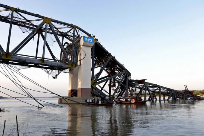
Those who live by waterways are most at risk of being severely affected by earthquakes due to the unstable soil. Therefore, there is great fear among experts of the potential for serious damage to Mandalay and Sagaing City.
“In Mandalay there are many high buildings and it is a high-risk city for earthquakes, yet they build many storeys,” said Mr Murugesan. “Also in Mandalay near the riverside there is a high potential for damage, we are very worried about that.”
He said the large city of Mandalay with its high-rise buildings should be made “earthquake resistant” and the authorities need to bring in the necessary building controls.
Preparing for disaster